News Alert: New ePCR Integration Simplifies EMS Data Management and Enables Better Care Coordination
How EMS Agencies Can Reframe Need and Refocus Resources With Geospatial Analytics
One of the biggest benefits of geospatial analytics is its ability to identify areas with socio-economic disparities and high emergency call volumes. Having this information can help EMS agencies improve operational and clinical performance.
Was this information valuable?

The Emergency Medical Services (EMS) industry is facing a myriad of challenges, with most agencies under pressure to improve response times while operating on shoestring budgets and navigating complex reimbursement rules. With the advent of geospatial analytics, EMS agencies have a powerful tool to help conquer these issues and enhance operations, especially when addressing disparities in access to care and optimizing resource allocation. When leveraged strategically, geospatial analytics can potentially unlock more funding for EMS agencies.
Identifying Social Disparities and Emergency Hot Spots
One of the biggest benefits of geospatial analytics is its ability to identify areas with social disparities and high emergency call volumes. Having this information helps EMS agencies improve operational and clinical performance.
By mapping call data against socio-economic indicators, agencies can identify where EMS usage is highest. Underprivileged areas have above-average reliance on EMS services, which slows response times. In one U.S. national study1, patients in cardiac arrest from the poorest neighborhoods experienced 10% longer EMS response times, which were less likely to meet national benchmarks.
Low-income areas are populated by Medicaid patients who use EMS and hospital emergency departments as their primary healthcare providers, because clinics are overwhelmed on a day-to-day basis; whereas more affluent areas do not rely on EMS as much because they have healthcare plans that provide more choices for care and make it easier get a prompt appointment with their primary care physician. With this social disparity data in hand, agencies can “draw a circle” around geographic areas where resources are needed most.
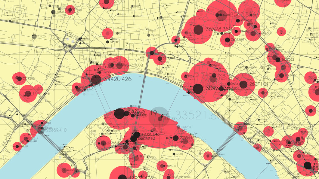
Similarly, geospatial analytics can reveal where emergency calls are clustered. For example, EMS agencies can use call data to compare where overdoses are occurring versus where patients live. Overdoses typically occur in a specific, urban area — such as a train station or public park — miles away from patients’ home addresses. If EMS agencies know where a high volume of emergencies are called in, they can prepare to deploy to that area.
In short, geospatial analytics help EMS agencies know where their services are needed most so they can allocate resources accordingly. This translates to quicker response times in high-demand areas and opens the door for agencies to collaborate with the broader community on ways to reduce the strain on emergency services in hot spots.

The image on the left illustrates opioid overdoses that usually occur in a specific socio-economic area, typically with a higher rate of disadvantage or a transient population; such areas may also be along major roadways. The image on the right identifies cardiac STEMI patients and illustrates that the population is equally dispersed among all neighborhoods and socio-economic classes.
Illustrating the Need To Increase Funding
Many EMS agencies struggle with funding, particularly when serving areas with a high proportion of low-income residents with limited insurance coverage. This financial strain is exacerbated by the lower reimbursement rates for Medicaid patients compared to those covered by Medicare or private insurance. It’s a constant battle for agencies to simply meet their base rates and remain financially viable.
Data is the key to helping EMS agencies strengthen their advocacy efforts and gain more funding. With geospatial analytics, EMS providers can show political officials, grant makers, and community stakeholders compelling, data-driven narratives about why there’s a critical need for funding. It’s much easier to prove the need for more training, equipment, and resources with clear illustrations of how the agency is serving the community — using hard facts and data about everything from the number of respiratory emergencies and how many times a particular medicine was administered to where cardiac arrests and overdoses are happening.

Leveraging geospatial analytics, agencies can advocate for more equitable funding distributions that reflect the demand and healthcare needs of different communities. For example, using data from the Department of Health, we could review mechanisms of injuries instead of looking at socio-economical demographics. Also, motor vehicle collision data could be used to obtain funding from various sources. Using visualization, it's easy to identify where something needs to be done to help make roads safer regarding car seat and seat belt usage, roadway design, and more.
Advancing Performance Management
The potential of geospatial analytics extends to performance measurement and improvement. EMS agencies can use geospatial analytics to monitor and analyze response times, patient outcomes, and service quality across different regions, identifying areas for improvement and best practice implementation. This ongoing evaluation helps agencies determine if performance meets both internal and external standards. The data will not only support funding requests like described above but will foster trust and accountability with the community.
The Future of EMS Is Rooted in Data
Geospatial analytics offers EMS agencies a tool to adapt and thrive in an increasingly complex healthcare landscape. By leveraging geographic and healthcare data, agencies can improve operational efficiency, advocate for necessary funding, enhance patient care, and contribute to broader public health goals.
Read more about the benefits of geospatial analytics in our article, “Improving EMS Agency Operations Through Spatial Analysis and Bio-surveillance.”
1National Library of Medicine (National Institute of Health (NIH)) website, Nov. 30, 2018, https://pmc.ncbi.nlm.nih.gov/articles/PMC6324393/. Accessed 11 Dec. 2024.
Related Posts
4 Must-have Data Points for Dispatch-Billing Alignment and Maximum Reimbursement
How STAT MedEvac Connected Device, Software, and Data Technology To Enhance QA and Elevate Care
ZOLL Pulse Blog
Subscribe to our blog and receive quality content that makes your job as an EMS & fire, hospital, or AR professional easier.
ZOLL Pulse Blog
Subscribe to our blog and receive quality content that makes your job as an EMS, fire, hospital, or AR professional easier.


